
Everyone: “It hasn’t snowed this much since ‘78!”
According to Hamilton County’s Hometown Meteorologist Paul Poteet, the county will see rain showers today. There will be some freezing rain and sleet mixed in from late Wednesday afternoon into early Thursday morning. Then the snow begins, and it’s all snow all the time on Thursday.
Winds will be gusty Wednesday night and Thursday, which could be an issue with any potentially ice-coated limbs and power lines. Blowing snow Thursday may be an issue with keeping the roads clear.
Click here to see Paul’s Huge Radar!
This evening, The Reporter will release a Special Early Edition of the “Hello, Hamilton County” video. Visit us on Facebook to watch.
Two-day forecast for Hamilton County according to the National Weather Service
Current as of 9:42 p.m. on Tuesday
Humor provided by Paul Poteet
Wednesday
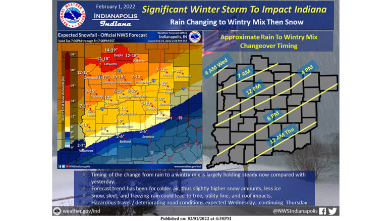
Colder. Rain, possibly mixed with snow in the morning, then snow, possibly mixed with rain and freezing rain in the afternoon. Snow may be heavy at times in the afternoon. Snow accumulation of 1 to 5 inches. Highs in the upper 30s. Temperature steady or slowly falling in the afternoon. North winds 5 to 15 mph. Gusts up to 20 mph increasing to 30 mph in the afternoon. Chance of precipitation near 100 percent.
Wednesday Night
Colder, snow. Patchy blowing snow toward daybreak. Snow accumulation of 4 to 5 inches. Lows around 19. North winds 15 to 20 mph with gusts to around 30 mph. Chance of snow near 100 percent.
Thursday
Colder, snow. Areas of blowing snow. Snow may be heavy at times in the morning. Moderate snow accumulations. Near steady temperature in the lower 20s. Northeast winds 15 to 20 mph with gusts to around 35 mph. Chance of snow near 100 percent.
Thursday Night
Colder. Mostly cloudy. A 20 percent chance of snow through midnight. Lows around 8. North winds 10 to 15 mph with gusts to around 25 mph. Wind chill readings 5 below to 5 above zero.
Cross-county prep underway
The Reporter reached out to various government entities around Hamilton County to find out how each is preparing for the oncoming winter storm.
Atlanta
Provided by Jennifer Farley, Atlanta Clerk-Treasurer
The Town of Atlanta begins preparing for winter weather in the early fall. Equipment is inspected and repaired or replaced if needed. We are prepared for the winter storm that is on its way. We have an ample supply of salt. Trucks are fueled, and plows and salt spreaders are mounted. Street Superintendent Andy Emmert has years of experience and does a great job maintaining the streets.
Jackson Twp. Fire
Provided by Fire Chief John Moore
Jackson Township Fire Department has been preparing for the winter storm by ensuring all equipment is in top operational readiness, all apparatuses have been checked and rechecked, along with adding additional personnel to each shift.
Staff has stocked the station with house staples, and well as prepared their cold weather gear. Medic units are stocked well with linens, hot packs and medical equipment for patient comfort.
Station 355 is ready for whatever may come to our area. Jackson Fire has competent and versatile staff that no matter what they may face, and they will overcome anything with the utmost confidence and competence.
White Rive Twp. Fire
Provided by Fire Chief Garry Harling
White River Township Fire Department is actively prepared for the upcoming winter storm.
The Department will respond with an ambulance and fire engine on each run and will be led by Utility 331. Utility 331 is equipped with a snowplow and it will make sure the road is prepared for the emergency equipment to respond anywhere in White River Township or neighboring departments.
Our volunteer staff will also be housed on station to assist all full-time personnel on all emergency calls.
Carmel
The following information describes the City of Carmel’s guidelines for snow removal and was provided by Carmel City Council member Adam Aasen in his email newsletter.
Up to 3 inches of snow
The city salts and/or plows only main streets such as Range Line Road, Main Street, Gray Road, Spring Mill Road, 116th Street, etc., and secondary streets such as Brookshire Parkway, Lakeshore Drive East and West, Adios Pass, Avian Way, etc.
3 inches or more of snow
Main and secondary streets are salted and/or plowed as the snow falls. After the majority of the snowing, blowing, or sleeting has ceased, a complete city plow is started with every street in the city being plowed. (Cul-de-sacs are not always plowed out completely. This is usually only done when the snowfall is considerably more than 3 inches.) Salting is routinely done only on main and secondary streets. Bridges, hills and intersections are salted as needed.
It takes approximately 24 hours to plow all 560 miles of streets and over 1,100 cul-de-sacs in the city.
* * *
If your mailbox has been damaged by Carmel snowplows, please call the Street Department at (317) 733-2001 to arrange for a replacement.
Find more helpful information on the City of Carmel Facebook page.
Noblesville
Provided by Robert Herrington, Noblesville Communications Manager
Noblesville Street Department crews began pretreating the roadways with brine on Monday. On Tuesday morning, crews started 12-hour day and night shifts that will continue daily until the winter storm has passed and roads are clear.
Once the snow begins, the city’s primary focus is to make sure that first responders can reach residents in the event of an emergency. The Noblesville Street Department is in constant contact with Hamilton County Dispatch and Noblesville Police and Fire. If there is an emergency, they can respond to help clear a path for emergency vehicles.
Residents can assist the city by not parking on the street. When clearing snow off their driveway, residents are asked to throw it to the side and not into the road, which potentially could be plowed back onto driveways.
Residents can also assist the city by being patient. Once snow begins, crews run full-time to clear more than 600 lane miles in the city from curb to curb. During snow removal, the city is broken into three categories. Crews do not move to the next level until the one before it is completed:
- Primary – main roadways and major arteries for traffic.
- Secondary – main roadways in neighborhoods, minor roads throughout the city with lower traffic counts.
- Alternate – lowest traveled roads and the city’s more than 500 cul-de-sacs.
Also, not all roadways in Noblesville fall under the city’s jurisdiction. These include those under the jurisdiction of INDOT (State Roads 19, 32, 37 and 38) and numerous Hamilton County roads. There also are private roads that have agreements with the city that they will maintain and remove snow.
Stay up to date by following the City of Noblesville Facebook page.
Westfield
From Westfield Street Superintendent Travis Stetnish; provided by Chris Proffitt, Westfield Communications Director
Most of you are probably aware of the snow event that is headed our way. It is too early to pinpoint exactly how much and timing.
The Westfield Street Department is watching it closely to determine our best plan of attack. We know that this event is going to start as rain and then temps will drop to below freezing. That being the case, our brine would not be effective.
A Street Department crew used treated salt on Tuesday. This will be less likely to completely be washed away with the rain.
A second crew came in at midnight Tuesday night. This is the crew that started the 12-hour shifts. The shift change time will be noon and midnight. The crews will remain on 12-hour shifts until the end of the snow event.
I have been in contact with both contractors, and they are ready and watching weather as well. I will be sending out multiple updates through this event.
Click here to see a video update from Travis Stetnish on the City of Westfield Facebook page.
Fishers
The Reporter’s attempts to reach the City of Fishers were unsuccessful. Check the City of Fishers Facebook page for any updates.