
Severe thunderstorms can include damaging winds in excess of 58 mph and hail 1 inch in diameter (approximately the size of a quarter).
Winds can be generated from a gust front like what caused the Indiana State Fair stage collapse in 2011, a downdraft where a column of air is no longer supported in the updraft of a storm and collapses sending air straight down at high speeds.
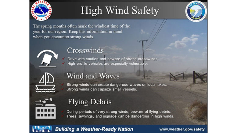
Occasionally, straight line wind damage from strong thunderstorms can cause significant damage with wind speeds that can exceed 100 mph. Winds can also be associated with changes in weather systems as like what has been seen recently during several high wind events.
The safest place during high winds is indoors. If you are outside, take cover next to a building or sturdy shelter. Flying debris is the main threat during high winds. You can help prevent flying debris by securing items like lawn furniture, trampolines, yard decorations and trash cans.
Hail is another threat during severe weather. If a thunderstorm builds high enough, it can carry water in the updraft to freezing air aloft, begin to fall, and can get caught in a cycle. The longer the droplets are in the cycle, the larger the hailstones. Eventually, the hail becomes too heavy for the storm to support and it falls to the ground.
Severe hail is considered to be 1 inch in diameter and can begin to cause damage. The largest hailstone ever record in the United States was nearly the size of a volleyball. It is possible for hail to become large enough to cause severe damage and even cause causalities.
Remember, if a severe thunderstorm or high wind watch is issued, it means conditions are favorable. If a severe thunderstorm warning or high wind warning is issued, it means to take shelter.
You can learn more about wind safety at weather.gov/safety/wind.