

WISH-TV | wishtv.com
All eyes are on the weather this weekend: A potent storm system will head towards Hamilton County and bring heavy snow, some areas of ice, rain and strong winds.
As of press time, the forecast for Saturday indicates snow will arrive early in the morning and start as a mix. The dividing line for snow will be Interstate 70 for much of the day. Steady snow will fall with freezing rain, and rain in southern Indiana. Winds will gust to upwards of 30 to 35 mph, limiting visibility and creating blowing and drifting snow.
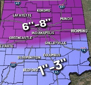
Graphic provided by WISH-TV
Winds will drag in bitterly cold air with temperatures falling to the lower teens overnight, transitioning everything to snow. Snow accumulation will range from 6 to 8 inches from Indianapolis and north, with a heavier band setting up north of the city possibly producing 8 to 10 inches.
Ice accumulation could range between 0.1 and 0.2 inches south of Interstate 70.
But what will it take for this storm to make it a blizzard?
According to WISH-TV Meteorologist Tara Hastings, to declare a winter storm a blizzard, there must be strong winds and low visibility. The National Weather Service will issue a blizzard warning when winds are sustained or gust 35 mph or greater. There must also be considerable falling or blowing snow, enough to reduce visibility to a quarter-mile or less. The strong winds and low visibility must last for at least three hours or more to be considered a blizzard.
The most recent blizzard warning Indianapolis had was Dec. 26, 2012, when most of central Indiana saw from 8 to 12 inches of snow and winds gusted to 40 mph.
This Saturday, winds will start at from 10 to 20 mph but increase during the afternoon. By Saturday evening, winds could gust to from 30 to 35 mph.
So, it’s going to be close as to whether or not Indiana will see blizzard conditions.