
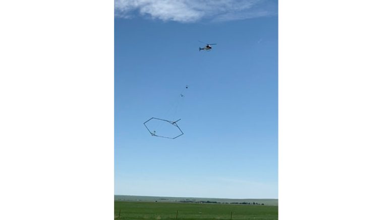
In late-September to early October, residents across northern Hamilton County may notice a low-flying helicopter with a unique hexagonal frame under it embarking on a groundbreaking mission to map groundwater supplies. This specialized equipment is part of an innovative project designed to enhance our understanding of groundwater aquifers and subsurface geology, ensuring sustainable water management for the region.
Indiana American Water (INAW) is partnering with the experts at Aqua Geo Frameworks (AFG) and INTERA Inc. to conduct these aerial surveys, a crucial step towards a deeper understanding of the region’s groundwater resources.
Groundwater is a vital resource, and enhancing knowledge of local aquifers is essential for safeguarding current supplies and identifying potential new water sources.
“This project marks a significant investment in our mission to protect Indiana’s precious groundwater resources,” INAW President Matt Prine said. “With advanced technology, we can better map and understand our aquifers, ensuring sustainable water management for our growing communities now and in the future.”
The advanced mapping technique has been successfully employed in other areas of the country, providing valuable data that supports the responsible management of natural resources nationwide. The SkyTEM scientific equipment, suspended about 100 feet below the helicopter in a ‘spider web’ array, is designed to map geological structures and groundwater resources up to 900 feet below the surface.
Once the flights are completed, AGF and INTERA will analyze the data to create a comprehensive report. This report will guide INAW in detailed groundwater mapping and hydrogeological studies, paving the way for informed water management decisions.
Pilots specially trained in low-level flying will navigate a carefully planned flight path to obtain the most accurate underground data. LiveWire Aviation, based in Homosassa, Fla., will conduct low-level aerial surveys using specially trained pilots. The helicopter will follow a planned route to gather underground data, focusing on open spaces and avoiding residential areas, livestock, and buildings. LiveWire Aviation operates under FAA regulations, including parts 135, 133, and 137.
looking at areas where they can come in and take our water?